
INTEGRATED MANAGEMENT OF LAND BASED ACTIVITIES
IN THE SûO FRANCISCO RIVER BASIN PROJECT
ANA/GEF/UNEP/OAS
Activity 1.1.C Ù Evaluation of the Contribution of the Lower SÐo Francisco
River's Navigational Route to the Agriculture Competitive
Enhancement in the Basin-AL/SE
Executive Summary of the Final Report
EVALUATION OF THE CONTRIBUTION OF THE LOWER
SûO FRANCISCO RIVER'S NAVIGATIONAL ROUTE TO
THE AGRICULTURE COMPETITIVE ENHANCEMENT IN
THE BASIN-AL/SE
Instituto Mineiro de GestÐo das êguas
Belo Horizonte Ù MG
INTEGRATED MANAGEMENT OF LAND BASED ACTIVITIES
IN THE SûO FRANCISCO RIVER BASIN PROJECT
ANA/GEF/UNEP/OAS
Activity 1.1.C Ù Evaluation of the Contribution of the Lower SÐo Francisco
River's Navigational Route to the Agriculture Competitive Enhancement in
the Basin-AL/SE
Executive Summary of the Final Report
EVALUATION OF THE CONTRIBUTION OF THE LOWER
SûO FRANCISCO RIVER'S NAVIGATIONAL ROUTE TO
THE AGRICULTURE COMPETITIVE ENHANCEMENT IN
THE BASIN-AL/SE
Coordination
Paulo Godoy
Departamento de Hidrovias
MinistÕrio dos Transportes
Consultant
Nathercia Schneider
Contract CPR/OAS No PO #50883
February 2003
EVALUATION OF THE CONTRIBUTION OF THE LOWER
SûO FRANCISCO'S NAVIGATIONAL ROUTE TO
AGRICULTURE COMPETITIVE ENHANCEMENT IN THE BASIN
EXECUTIVE SUMMARY
INTRODUCTION
Activity 1.1C, "Evaluation of the Contribution of the Lower SÐo Francisco's Navigational Route
to Agriculture Competitive Enhancement in the Basin" is inserted into Component I
(Environmental Assessment of the Basin) of the Integrated Management of Land Based
Activities in the SÐo Francisco River Basin Project (GEF/ANA/OAS/UNEP). Its objective is to
assess the alternative use of hydroways, in conjunction with other transportation modes, as a
factor of enhancement of the Basin's agriculture competitiveness, especially in Western and
Southwestern Bahia.
The work was carried out under the technical coordination of the Directory of Hydroways'
Infrastructure, of the Ministry of Transportation. It was focused on the identification of the loads
produced within the area of influence of the SÐo Francisco's Hydroway and in the possibility of
transporting them by boat. It also viewed the evaluation of the advantages of using multi-modal
transportation, after the enhancement of navigation the River. It compared transportation costs of
the production, with and without consideration of the hydroway, as well as its impacts on the
agricultural production in the Region, in the search for a greater economic efficiency.
Thus, this Report aims at a more effective contribution to the Integrated Management Program, to
be elaborated based on secondary data from the developed researches. This allowed a more
precise and objective analysis of the current situation in the SÐo Francisco Basin, regarding the
outflow of the regional production.
Basically, it is composed of nine main chapters, focusing on the characteristics of the SÐo
Francisco River, on its transport network; on the interior hydroway transportation; in a general
way, and on the SÐo Francisco Hydroway in particular; on the analysis of current and potential
alternate comparative scenarios of transportation modes in the basin; on the used simulation
model and on the proposal for outflow transportation of the Region's agricultural production.
The outcome of this analysis and diagnosis is presented in the form of conclusions and basic
recommendations for the SÐo Francisco Basin's Integrated Management Program.
1.
THE SûO FRANCISCO BASIN
1.1. GENERAL CHARACTERISTICS
The SÐo Francisco Basin, objective of the study, with a 634,000 kmý, represents 7.5% of the
National territory and is divided into four main sub-regions, as shown in Figure 1.
i
Figure 1. Sub-divisions of the SÐo Francisco's Basin
2. TRANSPORTATION SYSTEM NETWORK IN THE AREA OF INFLUENCE OF
THE SûO FRANCISCO BASIN 1
The transportation system is understood as a composition of sectors, designated as modes, which
include roadways, waterways, airways, railways, pipeways and urban transportation.
The aquatic mode, object of this work, is composed by the areas of Long Course Navigation,
Interior Navigation, Naval Construction and Ports, which are interdependent and complementary.
The focus here will be on Interior Navigation. The study will analyze the interaction among
modes which will provide the best logistics to production outflow from the area of influence of
the SÐo Francisco's Hydroway. Therefore, it is fundamental to know the existing transportation
infrastructure in the Region.
1 Data obtained from GEIPOT/MT's site, 2000.
ii
In short, it is known that (i) all States in the area of influence of the SÐo Francisco's Hydroway
have road networks in medium to bad conditions and (ii) the hydroway is navigable in the Sates
of Minas Gerais, Bahia and Pernambuco, but its reaches in Alagoas are in an advanced stage of
accretion of riverbed level, due to sedimentation processes.
The States of Minas Gerais, Bahia and Pernambuco have operating railroad networks. The Ports
considered in the study were those of BaÚa de Todos os Santos (BA) and Suape (PE).
3. INTERIOR HYDROWAY TRANPORTATION
In their majority, the navigable rivers run through regions known as the "great empty areas",
where there is little attractiveness for investments, which would allow them in the market, as
production centers. Therefore, interior navigation, proper for transporting great loads, was set
apart, short of investments which would assure its continuity.
Today, the interiorization process, driven by the expansion of agricultural and mineral frontiers,
reached the area of influence of our rivers. They convey the outflow of grains, minerals, lumber,
oil products and construction materials. In the way back, they bring, to the producing regions,
supplies and equipment, in a total load already above the 12 million tons a year.2
Areas that were uninhabited are being covered by cultures, by the big farms, or by mining camps.
In the biggest hydroways, traffic has begun to increase. Several ports located along the rivers
started to be re-equipped for handling the production from the new agricultural poles.
Construction of infrastructure works, from North to South, in the Country, promotes the creation
of long navigable stretches, opening new horizons for the interior navigation.
Activities related to interior navigation implementation, supervision and control have been passed
to ANTAQ (National Agency of Hydroway Transportation), which began to operate in February
of 2002.
3.1. THE HYDROWAY CONCEPT
By concept, Interior Hydroway Transportation, or Interior Navigation, is that done in natural or
artificial waterways, into the continents, especially in rivers and canals.
A potentially navigable river requires relatively low financial investments, to become a
hydroway. The biggest costs are located in specific points (critical points) along the river, such as
rapids, rocky parts, curves with short radius and points with insufficient depth.
The water course complying with the conditions for navigation, allowing the transit of larger
vessels is denominated an interior navigable way and might become a hydroway, by means of a
declaratory act of the public powers.
3.2. CHARACTERISTICS OF THE INTERIOR NAVIGATION TRANSPORTATION
Interior hydroway transportation is especially useful for conveyance of great volumes of cargo,
through long distances (bulk solid and liquid cargoes, containers, etc.). It presents specific
characteristics that make it attractive, from an economic point of view.
2 Only 0.48% of the total loads in the World are transported through hydroways.
iii
Among those characteristics, it is worth mentioning the following: (i) very low maintenance
costs, making it very economic (the situation improves as the use of the mode intensifies); (ii)
great capacity; (iii) lower fuel consumption (the good physical conditions of the waterways Ù
minimum friction, horizontal planes Ù do not require great power per transported ton; and (iv)
less expensive freights.
3.3. CHARACTERIZATION OF LOADS WITH VOCATION FOR HYDROWAYS
The aquatic mode is proper for loads that do not require great transportation velocity high and
may be conveyed in large volumes. The loads known with a "vocation for hydroways" are,
basically, those with low added values and that may be transported in great volumes for long
distances (grains and agricultural supplies, for example).
3.4. BENEFITS FROM USING INTERIOR HYDROWAY TRANSPORTATION
As each mode has its own specific energetic use and particular environmental characteristics,
decisions concerning transportation impact the environment should be weighted before taken.
Environment and quality of life have been receiving more attention, leading to an increasing
demand, not only for a solids transportation system, but also for policies that take environmental
objectives into consideration.
Recent European studies have compared the social costs of sound and atmospheric pollution, land
coverture, construction/maintenance and accidents, per transportation mode. The aquatic mode
was the one with the least environmental impacts. In the sound pollution, accidents and land
coverture, it showed little or no impacts.
Analysis of the same loads carried by different modes showed that boats had fewer accidents,
consumed less energy, produced less pollutants emissions and were less annoying to the society.
The study's conclusions showed that aquatic transportation is environmentally safe and
contributes to a sustainable development, thus should be encouraged.
4. THE SûO FRANCISCO HYDROWAY
The SÐo Francisco Hydroway is composed of navigable reaches in the SÐo Francisco, Grande
(350 km) and Corrente (160 km) Rivers, being equivalent to the distance from BrasÚlia (DF) to
Salvador (BA). It is, perhaps, the most economic way of connection between the Northeastern
and Central-Southern Regions.
The Corrente and Grande Rivers allow navigation similar to that of the SÐo Francisco, both with
depths greater than 1.50 m.
With its Southern end located in Pirapora (MG), the SÐo Francisco Hydroway is interconnected,
by railways and roads, to the most important economic centers of the Southeastern Region, and is
part of the Central-Eastern Exports Corridor. To the North, in the neighbor towns of Juazeiro
(BA) and Petrolina (PE), the hydroway is connected to the main capitals in the Northeast.
iv
Picture 1. Beach and end of the rapids, in Pirapora-MG.
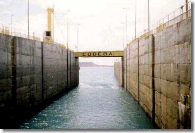
The SÐo Francisco Hydroway is controlled by the Administration of the SÐo Francisco River
Hydroway (AHSFRA), of the Ministry of Transportation. It is a federal mixed-capital society
that, besides making investments in the hydroway, operates the Ports of Pirapora and Petrolina.
Navigation in the hydroway was done mostly by the SÐo Francisco River's Navigation Company
(FRANAVE), a State company under the privatization process. The Company also executed
construction services and naval repairs, with a shipyard in the Ilha do Fogo, between Juazeiro and
Petrolina. Its fleet is composed by the "Benjamin GuimarÐes" ship, used in tourist trips, 12
tugboats, two motorboats, 64 barges, two derricks and a floating dike. There are few private
shipmakers operating on the riverine communities.
In the Corrente River Basin, there are hydro-agricultural projects under implementation that will
produce significant volumes of cargo in the future. The area of the Rio Grande (Bareiras)3 has an
expressive potential for cargo, especially soybeans. It is estimated in two million tons a year, the
cargo to be transported by hydroway, to Petrolina or Pirapora. Today, the river is not being used,
and the production is embarked in Ibotirama, taken there by the BR-242, or carried to BrasÚlia,
through the BR-020.
3 Making the Rio Grande navigable will make the road stretch to Ibotirama and the transference to boats unnecessary. Embarkment of the load at
the origin cuts down the freight.
v
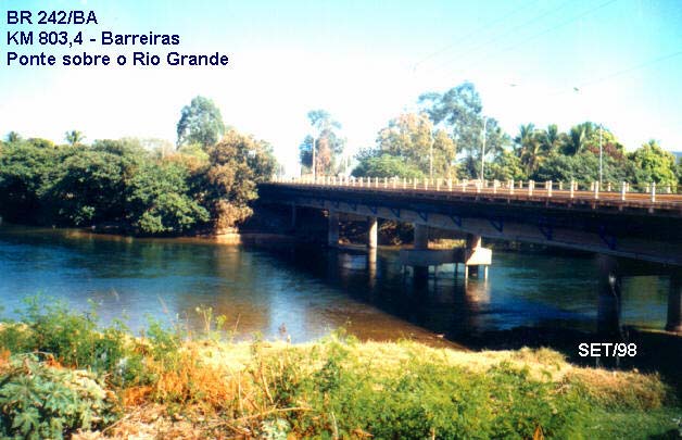
Picture 2. Bridge over the Rio Grande, in Barreiras (BA).
The most important ports in the Hydroway are: Pirapora/MG (connected by railway and roads to
the maritime ports of Vitµria/ES, Rio de Janeiro/RJ and Santos/SP, in the Southeastern Region);
Petrolina/PE and Juazeiro/BA (connected by railway to the maritime ports of Recife and Suape,
in Pernambuco) and Ibotirama (strategically located inn the intersection of the SÐo Francisco
River and the Salvador/BrasÚlia Highway.
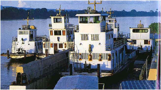
Picture 3. Boats in the Port of Pirapora (MG).
4.1. AREA OF INFLUENCE OF THE SûO FRANCISCO HYDROWAY
Analysis of the cargoes with a hypothetical vocation for hydroways, proved infeasible the use of
complementary highway transportation exceeding the 400 km, confirming the theoretical
statements on multimodal transportation.
vi
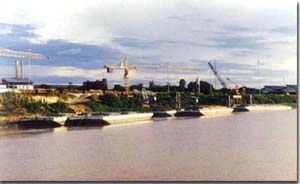
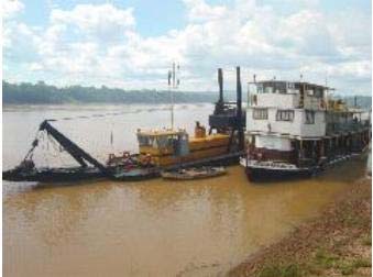
Picture 4. Unloaded hydroway convoy in the Petrolina Fluvial Port.
In this manner, the area of influence of the SÐo Francisco Hydroway was determined as that
covering the producing Municipalities in the States of Minas Gerais, Bahia, GoiÃs, PiauÚ and
Pernambuco, West and North of the River, with highway connections inferior to 400 km long.
To East and South of the hydroway, only the producers less than 100 km away from the River.
That was because the River runs parallel to the coast, always less than 600 km away from it. It
was assumed that, in the medium run, in view of the opening and modernization of the economy,
cabotage will exert a greater role in the modal distribution of transportation, attracting cargoes
close to the ocean.
Within this limitation, the considered cargoes are soybeans (grains), corn, soy bran, gypsite and
tomato pulp.
In the scenario of potential exchanges in the area of influence, the State of Pernambuco is present
as a producer of tomato pulp and gypsite, and consumer of corn and soy bran. Bahia is a corn,
soy (in grains, bran and oil) and tomato pulp producer, also a destination of the latter, and has
three export ports. Minas Gerais produces corn and consumes gypsite and tomato pulp. GoiÃs and
the Federal District are corn producers.
4.2. COMPOSITION OF THE NAVIGABLE ROUTE
ñ
The SÐo Francisco River
In spite of crossing, in most of its extension, a region subject to droughts, the SÐo Francisco River
is a permanent river, because its spring, as well as those of its main tributaries, are located in
regions with regular rainfall periods. In a normal year, it presents conditions for navigation,
between Pirapora and Juazeiro/Petrolina, throughout the year, with river depth varying according
to the rainfall regime.
vii
Figure 2 Ù Area of influence of the SÐo Francisco Hydroway and producing centers.
The River is navigable in its Middle Course, between Pirapora and Juazeiro/Petrolina. It also
presents a 200 km navigable stretch in its Lower Course, between its mouth and Piranhas (AL),
where, however, there is no regular commercial navigation.
The reach presents excellent depths, except in its estuary, and was used previously by maritime
cabotage ships, which would go up to Penedo (AL). The bridge in BR-101 Highway, connecting
viii
Proprià (SE) to Porto Real do ColÕgio (AL), includes a mobile module, which would allow the
traffic of such ship. This reach is, today, under an advanced sedimentation process.
The Middle SÐo Francisco presents a 1,371 km long navigable reach, between Pirapora and
Juazeiro/Petrolina, allowing the connection of the Southeastern and Northeastern Regions. In its
course, about 40 km from Juazeiro/Petrolina, it is located the Sobradinho Power Plant, with a
shiplock to overcome a 32.5 m upriver difference in water levels. This reach isolated from the
Lower course, by more than 200 km, given the great water level differences at the Paulo Afonso
Falls.
Picture 5 Ù Outlet to the Sobradinho Reservoir (upstream opening of the shiplock).
Given the differences in the physical characteristics along the navigable course, the Pirapora
(MG) and Juazeiro (BA)/Petrolina (PE) reach, is divided into the three sectors shown in Figure 3:
1st ) Pirapora (MG) to PilÐo Arcado Velho(BA):
This 1,015 km long segment, presents distinct conditions for the dry and the rainy seasons, with
river stages varying up to six meters.
During the floods, the river is wide and regular, with naturally navigable reaches. During the dry
season, the wet surface is narrower, the thalweg is developed between islands and mobile sand
banks along the channel, which is cleared as necessary, to maintain the hydroway safety.
There is also the occurrence of transversal rock formation and rocky sectors, as well as rocks
along the margins and isolated blocks in the bed, which are signalized with buoys, ensuring a safe
navigation. Regarding the sandbanks, it is estimated the need for dredging about 150,000 to
200,000 m° of sand, annually, depending on river conditions. At all the rocky sites there are
markings (signs and buoys) and, for some of them, there are studies related to the possibility of
removing the rocks.
ix
Figure 3 Ù Longitudinal profile of the SÐo Francisco Hydroway.
2nd ) PilÐo Arcado Velho (BA)to Sobradinho Dam (BA):
In this reach, navigation is done along the 314 km of the Sobradinho Lake, characterized as lake
navigation with excellent depths.
3rd) Sobradinho (BA) to Petrolina(PE)/Juazeiro/(BA)
A 42 km long reach, with width varying from 300 to 800 m and a 2.0 m depth, for a 1,500 m°/s
discharge flow from the Sobradinho Dam.
Navigation is practiced all along the Middle San Francisco River. In the 932 km reach, between
Pirapora and Barra (BA), navigation occurs in the free current. The 1.50 m depth in the channel is
maintained by the dredging of sandbanks.
The 230 km segment between Pirapora and SÐo Francisco (MG) is the one the greatest density of
floodplains. However, despite the maintenance dredging, it is not always stable nor with
sufficient depth, because of the releases made by the Trõs Marias Power Plant (MG).
The release of instantaneous minimum discharges of 500 m°/s, in compliance with agreements
with the Minas Gerais Electrical Energy Company (CEMIG), would be the ideal condition for
maintaining the desired depths, for navigation. Some of those floodplains are, sometimes,
limiting factors for the FRANAVE's convoys, that would rather dismember them at those points.
x
The reach also presents rocky passages that are to be worked to allow navigation of greater
proportions.
From Barra to Sobradinho (397 km), navigation is done in the Lake. It became more difficult for
the traditional SÐo Francisco boats to navigate there, as the intense winds create waves many
times incompatible with their safety conditions. The preferred route, close to the right margin, is
marked with blind reflective buoys. Transversal navigation is subjected o adverse conditions.
From the Dam to Petrolina/Juazeiro, for 242 km, navigation occurs in the free river current, in a
depth that, in normal years, is controlled by a 1,040 m°/s instantaneous flow. This flow is a
reference for the maintenance of sufficient depths, in the passages in which rocks were removed.
The segment has efficient floating signs.
The Sobradinho Dam created a 32.5 m difference in water levels, which is overcome through a
shiplock located in the right margin, with access in the downstream side through a 1,770 m long
canal. The dimensions of the shiplock are: length of 120 m, width of 17 m, 4 m of minimum
depth and minimum freeboard of 15 m, to allow the passage of convoys with 5,600 tons and 2.5
m drafts. The effective shiplock capacity is equivalent to 8 million tons, annually.
Even though the segment between Sobradinho and Juazeiro allows boats with 2.50 m drafts, the
reach with free current, upstream of Ibotirama (BA) is limited to 1.50 m depths, in the dry
periods.
Precarious navigation may occur in a 160 km long stretch, upstream of Juazeiro/Petrolina, up to
Santa Maria da Boa Vista (PE). It is a dangerous course, given the occurrence of numerous
transversal rock formations and rocky sectors that cause vortices, making it difficult to control the
boats. The Itaparica Dam, flooding a 160 km stretch, up to BelÕm de SÐo Fancisco (PE), turned it
navigable.
Between BelÕm do SÐo Francisco and Santa Maria da Boa Vista, there is a segment of about 115
m that cannot e navigated with the free current. Dams are to be constructed in the area, for power
production (Ibµ, in Pernambuco, and Pedra Branca, in Bahia).
ñ
Rio Grande
Analysis of navigation in the Rio Grande, resulted in classifying the reach into two segments with
the following characteristics:
- 1st segment (100 km long): from the river's mouth, in the City of Barra, up to BoqueirÐo,
close to the mouth of the Rio Preto;
- 2nd segment (266 km long): from BoqueirÐo to Barreiras.
In the first segment, navigation is easy. The six rocky portions do not present risks to navigation.
In terms of depth, it is necessary to install signs. There is road access (about 30 km long), starting
in Barreiras, that may be used for a road/fluvial terminal, cutting two days off the boats' round-
trips.
Upstream navigation may be feasible until about 40 km downstream from Barreiras, when a
sequence of tangent reverse curves begins. In these last 40 km, certainly, crossing of boats will
not be possible. The inclusion of this reach will limit the dimensions of the type-boat to be
defined, consequently reducing the economicity of the venture as a whole.
xi
The second segment present also favorable depths, gradually increasing its sinuosity and
decreasing width. Thos factors lead to the conclusion that the navigation pattern should be
reduced.
ñ
Rio Corrente
The Rio Corrente, from its mouth in the SÐo Francisco River to its origin, is 125 km long. Its
navigable reach runs from the its mouth to the City of Santa Maria da Vitµria, measuring 110 km.
It presents a regular width (about 80 m wide, in average) and a discreet sinuosity, with few
inadequate curves for the navigating boats. The existing sandbanks do not represent risks for the
current navigation.
The greatest obstacles are found at kilometers 88 and 92, where curves have radius smaller than
146 and 182 m, and central angles equal to 106¯ and 172¯, respectively. A critical impediment to
the navigation upstream from Santa Maria da Vitµria is a concrete bridge on Highway BA-172,
crossing the River right after the town.
At km 86, the curve is more restrictive, due to the existence of a sandbank emerging in the
convex part. The passage is close to the left margin, where the navigable channel is limited, 20 m
wide, but with adequate depth. Between kilometers 91.5 and 93.2, there are meanders, the only
one in all the river, with four reverse curves. The predominating width of 80 m does not present
restrictions to the practiced navigation. The narrowest widths in the river are 40 m, at km 55.6,
and 45 m, at km 85.2.
There are some restrictions related to the depth, at km 82.3, with a plain section all across the
river, for 150 m. Between kms 87 and 110, end of the navigable reach, in Santa Maria da Vitµria,
there are some floodplains, but all of them with depths superior to 1.60 m. These characteristics
are presented in Figure 4.
4.3. REGIONAL PRODUCTION WITH VOCATION FOR HYDROWAY
TRANSPORTATION
Even though the area of influence of the SÐo Francisco's Hydroway presents a well diversified
agricultural production, this analysis was limited to the part transportable through the hydroway.
Within this restriction., the cargoes to be considered are soybeans (grains and bran), corn, tomato
pulp, raw gypsite and fertilizers.
According to surveys, by FRANAVE, there is a potential load for transporting through the SÐo
Francisco's Hydroway in the order of 2.5 million tons a year. Of this total, about 85% would be
moved in the direction Pirapora/Ibotirama to Juazeiro/Petrolina, in the navigable course.
The identified loads are presented in Chart 1, with their origins, destinations and annual demands.
xii
Figure 4 Ù Scheme of the SÐo Francisco's Hydroway.
4.4. CURRENT SITUATION OF AQUATIC TRANSPORTATION IN BASIN
Today, given the hydroway conditions, the climatic events and FRANAVE's privatization
process, movement in the SÐo Francisco's Hydroway has decreased considerably. The factor
which contributed the most for this situation was the lack of competitiveness in the transport
operation. To assess the current situation, it is necessary to consider it into a historic context.
Chart 2 presents the movement in the Hydroway, in the 1988-1998 period, which was chosen in a
way to comprise technical and political events of interest. The last four years will be treated in
separate.
Chart 1 Ù Potential demand on the SÐo Francisco's
Hydroway, by product.
xiii
Product Demand
(ton)
Corn 577,200
Soy bran
707,900
Soy (in grains)
343,560
Tomato pulp
17,500
Gypsite 32,000
Fertilizer 54,390
TOTAL 2,513,550
Chart 2. Cargo transported through the SÐo
Francisco's Hydroway (1988-98)
Year
Transported volume (t)
1988 120,296
1989 93,592
1990 36,838
1991 45,180
1992 8,443
1993 8,692
1994 26,737
1995 10,912
1996 50,772
1997 35,787
1998 47,238
As it may be verified, the greatest cargo movement occurred in 1988, with a volume exceeding
the 120 thousand tons. With the reduction in transportation of gypsite and soy (grains), this
volume was continuously decreasing up to a point, in 1992, that it was less than 10 thousand tons.
In the past four years, considering the Country's political and administrative context, movement
in the highway has been kept around 60 thousand tons a year, in average, as presented in Chart 3.
Chart 3 Ù Volumes transported through Sobradinho's shiplockÙ 1998/2001
Year
Transported volume (tons)
Transportation (TK)*
1998 47,238 47,623,989
xiv
1999 65,610 50,114,891
2000 58,766 34,563,059
2001 60,631 35,542,892
Average 58,061
41,961,208
* TK means tons transported per kilometer, a characteristic unity used in transportation, being the result of the
multiplication of the load (ton) times the distance (km) / Source: AHSFRA (2002)
Considering the potential 2.5 million of annual tons for the SÐo Francisco's Hydroway, it is
inferred that transportation in the waterway is much bellow its capacity. That might be because
currently the mode presents no credibility to the users, as it operates without fulfilling the
minimum transport requisites, such as regular schedules, availability of convoys and adequate
drafts and terminals.
In spite of that, demands for transportation in this corridor may increase significantly and,
certainly, it would augment its participation if there were competitiveness in the sector, rendering
reliable services, with quality and fair prices.
The new ship-owners installed in the hydroway must offer more efficient convoys, with greater
load capacity. This would allow the owners of the cargoes to change their transport logistics,
providing the navigation companies with firm expressive volumes. It is important to provide a
reliable frequency of the regular routes and that the fluvial terminal be properly equipped,
maintaining qualified personnel, for the operation.
4.5. ESSENTIAL ACTIVITIES FOR THE FULL UTILIZATION OF THE HYDROWAY
FOR THE PRODUCTION OUTFLOW.
The essential activities for the full utilization of the hydroway include dredging, rocks removal,
signalizing and buoys, in addition to improvements in the terminals' infrastructure and in its
operational capacity.
The AHSFRA, responsible for the maintenance of the SÐo Francisco's Hydroway, has been
providing the services defined in the governmental programs. Among those, the following
deserve mention: (i) rock removal at Ressaca, Correnteza, Umburama, Roncador and Carinhanha;
(ii) clearing the navigation channel; (iii) placing fixed signs at the margins and buoys in the
Pirapora (PK 1982) - Juazeiro/Petrolina reach; (iv) installing telemetric limnetic stations. A
summary of the implemented works and studies is presented in Chart 4.
5. COMPARATIVE SCENARIOS OF ALTERNATIVE TRANSPORT MODES
(EXISTING AND POTENTIAL) IN THE BASIN
5.1 PROJECTION OF THE REGIONS'S AGRICULTURAL PRODUCTION
Given the uncertainties of the world economy and the direction taken by the Brazilian
Government, the growth targets of the Gross national Product (GNP) are being modified. In view
of this, the projection of scenarios for the SÐo Francisco Basin's agricultural production and the
xv
assessment of increase in profits base don reduced transportation costs, has become an almost
impracticable task.
Thus, a less pretentious economic analysis, the present study, used the effective demand and the
potential demand for loads with hydroway vocation in the SÐo Francisco, as basis for developing
a simulation model, to compare economies based on the use of multimodal transport in the
hydroway's area of influence, considering the same routes and cargoes currently practiced in the
Basin.
Chart 4 Ù Summary of Works and studies (concluded and scheduled) aimed at the use of
the SÐo Francisco's Hydroway as production outlet.
Concluded works and studies (1996-1999):
Works under way
ñ Fixed signs and buoys in the Pirapora to
Works and field services:
Juazeiro/Petrolina reach, annually updated;
ñ Extension and frequency of dredging works;
ñ Rock removal at Ressaca, Correnteza,
Umburama, Roncador and Cachoeira da
ñ Bathymetric surveys in the navigable reach
Carinhanha.
between Pirapora and Juazeiro/Petrolina, with
200 m spaced sections, altimetric reading and
ñ Periodic dredging of the high sand inverts
survey of operating fluviometric stations;
developed in the navigation channels, during low
flows periods.
ñ Study of the navigability on the SÐo Francisco
River, in the 500 km reach from Juazeiro-
ñ Installing fixed sign and buoys in the Pirapora -
BA/Petrolina-PE to the Itaparica Dam -BA;
Juazeiro/Petrolina reach. Continuous
signalization, correction and placement of buoys,
ñ Rio Grande Navigability Study;
keeping the river safe for navigation.
ñ Rio Corrente Navigability Study;
ñ Installing telemetric limnetic stations. Operational
ñ Restoration of the Fluvial Port of Pirapora, with
Monitoring Program, with surveys of critical
preventive maintenance of the derricks and
navigation points and Geographical Information
transporting belts, pier reforming and margin
System (GIS).
protection, with short vegetation;
Studies and projects:
ñ Restoration of the dredging facilities;
ñ Environmental impacts assessment (EIA-RIMA), ñ Implementation of a real time flows and stages
for Works in the SÐo Francisco River;
forecast scheme.
ñ Social Communications and Environmental
ñ Implementing a data collection scheme for the
Education for the riverine communities, where
Basin's network (CEMIG, CHESF, ANEEL),
rock removal was executed;
flood routing in the SÐo Francisco River and main
tributaries, using hydrodynamics modeling, flow
ñ Bathymetric survey of all the rocky sectors of the
and stage forecasts in control sections
river channel, to be used for support to flow
(fluviometric and limnetic stations) and in critical
forecasts, signalization and interventions in the
navigation sites (floodplains, rocky beds, etc.).
river canal;
ñ Basic studies for definition of Works and flows
ñ Hydrologic monitoring studies, related to the
required for maintenance of drafts.
hydrology, hydraulics and fluvial navigation.
ñ Elaboration of a diagnosis of he navigability
conditions in critical reaches, based on the results
of studies of outflow profiles; estimates of
required flows for maintenance of the 1.50, 2.00
xvi
and 2.50 m drafts, in critical sections.
ñ Determining the Works required for maintenance
of drafts (rocks removal, buttresses, guide-current
and dredging).
ñ Diagnosis of the regulation potential of the Power
Plants (Trõs Marias and Sobradinho), in order to
allow navigation (Operational rules).
ñ Determining the regulation potential of the
developments: Critical analysis of the operations
for power generation; estimates of oscillations of
flows during the day (peak hours to low
production hours) and the downstream
propagation of their impact; simulation of the
optimal operation of the developments,
considering the maintenance of minima depths of
2.0 and 3.0 m, in critical points; proposal of
operational rules for recovering the frequency of
occurrence of the full margin debt.
ñ Studies for measurement and diagnosis for
margin stabilization in the SÐo Francisco River.
ñ Survey of unstable margins in the navigable
reach; diagnosis of the reasons for the instability,
considering geological, geotechnical,
environmental (destruction of riparian vegetation)
and fluvio-geomorphological aspects;
determining the measures for margin
stabilization.
ñ With the objective of optimizing cargo
transportation in the SÐo Francisco Hydroway, the
flow of cargo, the integration between the diverse
modes, as well as their current costs are to be
studied.
ñ Assessment of the actual potential for cargoes
with hydroway vocation that may be transported
in the SÐo Francisco Hydroway, as well as their
flows and demands. This will be used to support
hydroway projets.
ñ Environmental Impact Assessments.
ñ Assessment of environmental impacts due to
proposed changes in the fluvial canal and to the
transit of cargo boats in the hydroway. Investigate
mitigating actions for the SÐo Francisco River.
In order to estimate what was called effective load for each of the products listed in Chart 5
(except for the gypsite), the mean transported volumes for the past years, in thousands of tons,
was used. For the gypsite, it was used the historic average for the last 10 years it was transported.
xvii
For the fertilizer, the value was provided by the PetrobrÃs. With regard to the potential or
projected load, the used values were provided by the FRANAVE. From these data, the results
presented in Chart 5 were obtained.
Chart 5 Ù Effective and projected loads used in the Simulation model.
Product Origin Destination Effective
Potential
load
load
Barreiras Export
19.410
300.000
Soy
Soy
MG/GO/DF Export
19.410
43.560
Barreiras Northeastern Region
19.600
586.000
Soy bran
Soy bran
MG/GO/DF Northeastern
Region
19.600
121.900
Gypsite
Chapada Araripe
MG/DF
5.350
543.390
Corn
MG/GO Northeastern
Region
6.375
577.200
Tomato pulp
Juazeiro/Petrolina MG/GO/DF
7.129
17.500
Fertilizers
CamaÓari MG/GO/DF 3.000
543.550
5.2 CARGO
OUTFLOW
PROCESS
ñ Soy (in grains)
The export route for soy in grains from the Barreiras Region (BA) and from the States of Minas
Gerais and GoiÃs, and from the Federal District is, currently, by highways or by road/railways.
Today, the production for export may be transported by truck to BrasÚlia, where it is transferred
to train wagons, of the Vitµria-Minas Railway, controlled by the Vale do Rio Doce Company.
From there, it is moved to the Port of EspÚrito Santo or it is transported in truck containers,
directly to IlhÕus. There are two alternatives for exporting the soy, but both depend on the
conclusion of works. The possible routes are:
1. The cargo picked up in Barreiras (BA) is taken to Ibotirama by Highway BR-242,
transferred to the SÐo Francisco's Hydroway and taken to Petrolina (PE). There It is
transferred to the Transnordestina Railway and taken to Salgueiro (PE), entering the
CSN network in the way to Suape.
2. The cargo is picked up in Barreiras, taken to Ibotirama by Highway BR-242, transferred
to the SÐo Francisco's Hydroway and taken to Juazeiro (BA). There it is transferred to
the FCA Railway, going to the Ports of Baia de Todos os Santos. In both cases, cargo
from Minas Gerais, GoiÃs and federal District would be picked up in Pirapora (MG).
The first alternative depends on the construction of a 230 km segment of the Transnordestina
Highway (Petrolina - Salgueiro), on improvements on 607 km of the CFN network (from
Salgueiro to the Port) and of enhancement of portuary facilities in the Port of Suape. The second
depends on adaptations in the Ports of Baia de Todos os Santos, for better handling export cargo.
ñ Soy Bran
In the area of interest, there are two alternative ways of transport for the soy bran, with four main
routes for the Northeastern Region, particularly to the States of Pernambuco and Cearà (two
xviii
highway only routes and two combined highway-railway). In the first case, there are the routes
starting in Barreiras, serving the Cargill and Ceval enterprises.
In the exclusively on-highway route, the soy bran is transported in 28 tons trucks, in 3-day trips,
for 2,000 km of paved highways, in a fair state of conservation. In the combined highway-railway
route, 300 km are covered by truck, from Barreiras to Ibotirama. The cargo is then embarked in
convoys, traveling 604 km down the river, for 7 days, to Petrolina, where it is disembarked and
distributed by truck in an 800 km radius area.
The second alternative includes the routes originating in UnaÚ (MG), Paracatu (MG), Cristalina
(GO) and BrasÚlia, besides other towns where the soy crushing facilities are located, in the
Central Western Region.
ñ In the exclusively highway route, the soy bran would be transported in 28 tons trucks, i
6-day trips, through 2,700 km in fairly conserved paved roads. In the intermodal route,
the cargo would be transported through 400 to 500 km, by truck, from its origin to
Pirapora. There, it would be embarked in 1,600 tons convoys, and go down the river for
1,371 km, in 20 to 30 days, towards Petrolina, where it would be disembarked and
distributed, by truck, in an 800 km radius area.
ñ Gypsite
The transportation routes connect the gypsite production area, in the Araripe Plateau, to the
consumer centers, represented by the cement industries located in Montes Claros, Pedro
Leopoldo and Matozinho, in minas Gerais, and in BrasÚlia (DF).
The exclusively highway route for the outflow of gypsite runs through 2,550 km of paved roads,
in regular to precarious conditions.
In the intermodal route, the cargo is carried through 260 km, by trucks, between its origin and
Petrolina. It is then embarked in fluvial convoys, traveling 1,371 km to Pirapora, where it is
disembarked, to be distributed by truck, in a 450 radius area.
xix
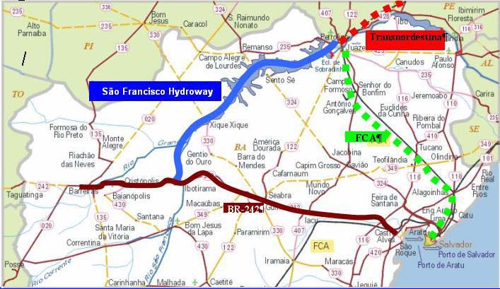
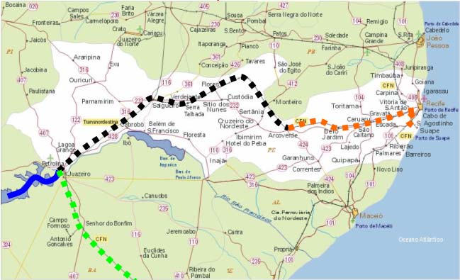
Figure 5 Ù Outflow routes for Western Bahia's soybean (grains and bran).
Figure 6 Ù Outflow routes for Pernambuco's soybean (grains and bran).
ñ Tomato pulp
xx
The natural route for the tomato pulp is by highway and railway, in view of the location of the
product's industries, in Petrolina/Juazeiro. After embarked in convoys, the barrels are transported
to Pirapora and disembarked in courtyards, where they may be kept in storage or loaded in trucks,
t travel 700 km, towards Patos de Minas, AraÓatuba and Cajamar (MG), where the producers of
tomato extract and derivatives are located. Opting for exclusively highway route, the ground
distance, from origin to destination, is around 1,800 km.
ñ Corn in grains
The route for transporting corn in grains are those connecting the producing regions, in Minas
Gerais and GoiÃs, to the Northeastern Region. The exclusively high way route's extension is
around 2,500 km, from origin to destination. In the multimodal route, the corn, like the soy bran,
is transported by truck, for 400 to 600 km, from the origin to Pirapora, where it is embarked in
convoys, going down the River, to Petrolina. From there, it is distributed by truck, to distances as
far as 800 km.
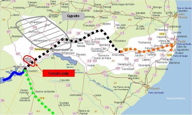
Figure 7 Ù Outflow of gypsite and tomato pulp.
ñ Fertilizers
Today, this product is transported entirely by truck, through a 1,600 km distance, between
CamaÓari (BA) and the points of consumption. The intermodal route would include a highway
reach of 600 km, between CamaÓari and Ibotirama, an aquatic reach, from Ibotirama to Pirapora,
and a railway portion, for the distribution in the States of Minas Gerais and GoiÃs, and in the
Federal District, with approximately 400 km.
xxi
5.3 SCENARIOS
SIMULATION
For evaluating the regional transportation flows, the routes were analyzed by type of
merchandise, taking into consideration the freights, CO emissions and fuel consumption.
Charts 6, 7 and 8 show the route simulation outcomes and the results of comparisons between the
current (effective) and the potential demands. The charts reflect the results of modeling the
reduction in transportation costs, the reduction in environmental costs and in fuel consumption.
Some of he information used in the simulation were obtained trough the FRANAVE, the
AHSFRA and in the PETCON Report, regarding the Study for FRANAVE's Destatization.
Information on the willingness to use the hydroway mode, the loads operated and the current
mode used for outflow of the production were obtained questionnaires answered by the users.
The current freight values were obtained from SIFRECA prices of December of 2002). Official
statistics on the planted area, conditions of the transportation network and productivity, as well as
other information found relevant, were also considered.
6.
THE SIMULATIN MODEL
The here presented simulation model is simply a tool for comparing economic costs (represented
in this study by the freight and cost of fuel) and environmental costs (represented by CO
emissions), resulting from the use multimodality, considering only the highway mode for
transporting the cargo.
There is no pretension to present a sophisticated mathematical model. The simulation uses simple
equations, allowing its use by any person interested in the comparison. Three distinct simulations
were run:
1. Assessment of the total transportation costs, directly through the freight prices, not
considering any other costs;
2. Assessment of environmental impacts of removing CO from the atmosphere; and
3. Regarding fuel consumption.
6.1 ROUTES
The routes considered in this study are originated in the centers responsible for producing the
loads (centers of production) and terminating at the points that absorb the products. The
extensions of the transport modes and the costs of transferring the cargoes were considered, as
well as fuel consumption and emissions of pollutants. The reduction in costs, due to the use of the
Rio Grande and Rio Corrente was not accounted for, as the investments for turning the ways
commercially navigable haven't been contemplated in the budget yet. Charts 6, 7 and 8 present
the simulation outcomes, regarding freight costs, fuel consumption and CO emissions.
7. PROPOSAL FOR TRANSPORTING THE REGIONAL AGRICULTURAL
PRODUCTION
According to the simulation results, the most efficient logistics for the outflow of each of the
products in compliance with the conditions defined in the evaluation, are presented ahead.
xxii
7.1. SOY (GRAINS) FOR EXPORT
For the soy in grains, all the simulations point to the route including the picking up in Barreiras,
with the transference to the SÐo Francisco Highway in Ibotirama and to the FCA in Juazeiro, on
the way to the Ports of Baia de Todos os Santos.
In a similar way, the loads produced in Minas Gerais, GoiÃs and in the Federal District wouls be
picked up in Pirapora, traveling in the SÐo Francisco Highway to Juazeiro and, from there, to the
Ports of Baia de Todos os Santos, using the FCA.
However, while the facilities in the Ports of Aratu and/or Salvador are not improved and the
requirements for navigation in the SÐo Francisco Highway are not fully met, a practicable
alternative would be the Port of IlhÕus. The cargo would be picked up in the same origins and
taken, by highway, to that Port. Some industries, with strong representation in the sector, already
devise the possibility and are investing in the Port's facilities, to allow the handling of heir
cargoes.
7.2. SOY BRAN
Regarding soy bran, as it is meant for local consumption, in the Northeastern Region, the options
were restricted to comparing alternative routes, with and without the hydroway. According to the
simulations, the routes including the hydroway present significant economic advantages, being
more suitable for transporting the production:
ñ Production in Western Bahia: Picking up in Barreiras, transference to the hydroway, in
Ibotirama, and distribution by truck, throughout the Region.
ñ Production in Minas Gerais, GoiÃs and Federal District: picking up in Pirapora,
transported in the SÐo Francisco Highway and distributed by trucks, in the local roads.
7.3. RAW GYPSUM
Given The product's characteristics and in view of the production centers being located along the
SÐo Francisco Highway, the recommended route for the outflow of the gypsite starts in the
Araripe Plateau, being transported by truck, to Petrolina, Transferred to the hydroway and taken
to Pirapora, from where it is distributed.
xxiii
CHART 6 Ù COMPARING ADVANTAGES OF USING THE MULTIMODAL ALTERNATIVE - FREIGHT
SOY (GRAINS)
ORIGIN DESTINATION REACH
MODE DISTôNCE
TOTAL COST
(Km)
(R$/t)
Barreiras
Port of Vitµria
Barreiras - BrasÚlia
Hyghway
630
45.05
BrasÚlia - Vitµria
Railway
1821
85.99
TOTAL 131.04
Barreiras
BaÚa de Todos os Santos
Barreiras - Ibotirama
Hyghway 220
16.57
Ibotirama - Juazeiro
Hydroway 604
21.50
Juazeiro - Salvador
Railway 572
29.41
xxiv
TOTAL 67.48
Barreiras Suape
Barreiras - Ibotirama
Hyghway 220
16.57
Ibotirama - Petrolina
Hydroway 604
21.50
Petrolina - Suape
Railway 837
41.42
TOTAL
79.48
Barreiras IlhÕus
Barreiras - IlhÕus
Hyghway
1000
75.30
MG/GO/DF
Port of Vitµria
MG/GO/DF - BrasÚlia
Hyghway 400
30.12
BrasÚlia - Vitµria
Railway 1821
85.99
TOTAL
116.11
MG/GO/DF
BaÚa de Todos os Santos
MG/GO/DF - Pirapora
Hyghway 400
30.12
Pirapora - Juazeiro
Hydroway 1,371
44.36
Juazeiro - Salvador
Railway 572
29.41
TOTAL
103.89
xxiv
MG/GO/DF Suape
MG/GO/DF - Pirapora
Hyghway 400
30.12
Pirapora - Petrolina
Hydroway 1,371
44.36
Petrolina - Suape
Railway 837
41.42
TOTAL
115.89
MG/GO/DF
IlhÕus
MG/GO/DF - IlhÕus
Hyghway
1650
124.25
SOY BRAN IN GRAINS
ORIGIN DESTINATION REACH
MODE DISTôNCE
TOTAL COST
(Km)
(R$/t)
Barreiras Northeastern
Barreiras - Ibotiram
Region
a
Hyghway 220
16.57
Ibotirama - Petrolina
Hydroway 604
21.50
Petrolina - NE Region
Hyghway 800
63.74
xxv
TOTAL
101.81
Barreiras
Northeastern Region
Barreiras - NE Region
Hyghway
1,800
135.54
MG/GO/DF Northeastern
Region MG/GO/DF - Pirapora
Hyghway 400
30.12
Pirapora - Petrolina
Hydroway 1,371
44.36
Petrolina - NE Region
Hyghway 800
63.74
TOTAL
138.22
MG/GO/DF
Northeastern Region
MG/GO/DF - NE Region Hyghway
2,700
203.31
CORN IN GRAINS
MG/GO
Northeastern Region
MG/GO - Pirapora
Hyghway 600
45.18
Pirapora - Petrolina
Hydroway 1,371
44.36
Petrolina - NE Region
Hyghway 800
63.74
xxv
TOTAL
153.28
MG/GO
Northeastern Region
MG/GO - NE Region
Hyghway
2,500
188.25
TOMATO PULP
ORIGIN DESTINATION
REACH
MODE DISTôNCE
TOTAL COST
(Km)
(R$/t)
Juazeiro/Petrolina MG
Juazeiro/Petrolina - Pirapora
Hydroway 1,371
40.86
Pirapora - MG
Hyghway 700
56.21
TOTAL
97.07
Juazeiro/Petrolina MG
Juazeiro/Petrolina - MG
Hyghway
1,800
135.54
FERTILIZERS
xxvi
CamaÓari MG/GO/DF
CamaÓari - Ibotirama
Hyghway 600
45.18
Ibotirama - Pirapora
Hydroway 765
26.30
Pirapora - MG/DF
Hyghway 400
33.62
TOTAL
105.10
CamaÓari
MG/GO/DF
CamaÓari - MG/GO/DF
Hyghway
1,600
120.48
GYPSITE
Chapada do Araripe
MG/DF
Chapada do Araripe - Petrolina Hyghway 260
12.00
Petrolina - Pirapora
Hydroway 1,71
39.50
Pirapora - MG/DF
Hyghway 450
21.00
TOTAL
72.50
Chapada do Araripe - MG/DF Hyghway
2,550
127.76
xxvi
CHART 7 Ù COMPARING ADVANTAGES OF USING THE MULTIMODAL ALTERNATIVE Ù FUEL
SOY (GRAINS)
ORIGIN DESTINATION REACH
MODE
DISTô
CONSUMP
NCE
TION (l/year)
(Km)
EFFECTIVE POTENTIAL
Barreiras
Port of Vitµria
Barreiras - BrasÚlia
Hyghway 630 226,224 3,496,500
BrasÚlia - Vitµria
Railway
1821
212,074
3,277,800
TOTAL 438,297 6,774,300
Barreiras
BaÚa de Todos os Santos
Barreiras - Ibotirama
Hyghway 220 78,999 1,221,000
Ibotirama - Juazeiro
Hydroway 604 29,309 453,000
Juazeiro - Salvador
Railway 572 66,615 1,029,600
TOTAL 174,923 2,703,600
xxvii
Barreiras Suape
Barreiras - Ibotirama
Hyghway 220 78,999 1,221,000
Ibotirama - Petrolina
Hydroway 604 29,309 453,000
Petrolina - Suape
Railway 837 97,477 1,506,600
TOTAL 205,785 3,180,600
Barreiras
IlhÕus
Barreiras - IlhÕus
Hyghway
1000 359,085 5,550,000
MG/GO/DF
Port of Vitµria
MG/GO/DF - BrasÚlia
Hyghway 400 143,634 322,344
BrasÚlia - Vitµria
Railway 1821 212,074 475,937
TOTAL 355,708 798,281
MG/GO/DF
BaÚa de Todos os Santos
MG/GO/DF - Pirapora
Hyghway 400 143,634 322,344
Pirapora - Juazeiro
Hydroway 1,371 66,528
149,302
Juazeiro - Salvador
Railway 572 66,615 149,498
TOTAL 276,777 621,144
xxvii
MG/GO/DF Suape
MG/GO/DF - Pirapora
Hyghway 400 143,634 322,344
Pirapora - Petrolina
Hydroway 1,371 66,528
149,302
Petrolina - Suape
Railway 837 97,477 218,758
TOTAL 307,639 690,404
MG/GO/DF
IlhÕus
MG/GO/DF - IlhÕus
Hyghway
1,650 592,490 1,329,669
SOY BRAN
ORIGIN DESTINATION REACH
MODE
DISTô
CONSUMP
NCE
TION (l/year)
(Km)
EFFECTIVE POTENTIAL
ORIGEM DESTINO
TRECHO
MODAL DISTôNCIA
CONSUMO (l/year)
(Km)
C, EFETIVA
C, POTENCIAL
Barreiras Northeastern
Barreiras - Ibotiram
Region
a
Hyghway 220 79,772 2,385,020
xxviii
Ibotirama - Petrolina
Hydroway 604 29,596 884,860
Petrolina - NE Region
Hyghway 800 290,080 8,672,800
TOTAL 399,448 11,942,680
Barreiras
Northeastern Region
Barreiras - NE Region
Hyghway
1800 652,680 19,513,800
MG/GO/DF Northeastern
Region MG/GO/DF - Pirapora
Hyghway 400 145,040 902,060
Pirapora - Petrolina
Hydroway 1,371 67,179
417,812
Petrolina - NE Region
Hyghway 800 290,080 1,804,120
TOTAL 502,299 3,123,992
MG/GO/DF
Northeastern Region
MG/GO/DF - NE Region Hyghway
2,700 979,020 6,088,905
CORN IN GRAINS
MG/GO
Northeastern Region
MG/GO - Pirapora
Hyghway 600 70,763 6,406,920
Pirapora - Petrolina
Hydroway 1,371 21,850 1,978,353
xxviii
Petrolina - NE Region
Hyghway 800 94,350 8,542,560
TOTAL 186,963 16,927,833
MG/GO
Northeastern Region
MG/GO - NE Region
Hyghway
2,500 294,844 26,695,500
(TOMATO PULP
ORIGIN DESTINATION REACH
MODE
DISTô
CONSUMP
NCE
TION (l/year)
(Km)
EFFECTIVE POTENTIAL
Juazeiro/Petrolina MG
Juazeiro/Petrolina - Pirapora
Hydroway 1371 24,435
59,981
Pirapora - MG
Hyghway 700 92,321 226,625
TOTAL 116,755 286,606
Juazeiro/Petrolina MG
Juazeiro/Petrolina - MG
Hyghway
1800 237,396 582,750
xxvix
FERTILIZERS
CamaÓari MG/GO/DF
CamaÓari - Ibotirama
Hyghway 600 33,300 6,033,405
Ibotirama - Pirapora
Hydroway 765
5,738 1,039,539
Pirapora - MG/DF
Hyghway 400 22,200 4,022,270
TOTAL 61,238 11,095,214
CamaÓari
MG/GO/DF
CamaÓari - MG/GO/DF Hyghway
1,600 88,800 16,089,080
GYPSITE
Chapada do Araripe
MG/DF
Chap. Araripe - Petrolina Hyghway 260 25,734 2,613,706
Petrolina - Pirapora
Hydroway 1,371 18,337 1,862,469
Pirapora - MG/DF
Hyghway 450 49,488 5,026,358
TOTAL 93,558 9,502,533
Chap. Araripe - MG/DF Hyghway
2,550 252,386 25,634,423
xxix
CHART 8 Ù COMPARING ADVANTAGES OF USING THE MULTIMODAL ALTERNATIVE Ù EMISSIONS
SOY (GRAINS)
ORIGIN DESTINATION REACH
MODE
DISTô
EMISSIONS (kg/year)
NCE
(Km)
EFFECTIVE POTENTIAL
Barreiras
Port of Vitµria
Barreiras - BrasÚlia
Hyghway
630
109.2
1,687.5
BrasÚlia - Vitµria
Railway
1821
1.8
27.3
TOTAL 110.9 1,714.8
Barreiras
BaÚa de Todos os Santos
Barreiras - Ibotirama
Hyghway 220 38.1
589.3
Ibotirama - Juazeiro
Hydroway 604
0.1
1.1
Juazeiro - Salvador
Railway 572 0.6
8.6
TOTAL 38.8
599.0
xxx
Barreiras Suape
Barreiras - Ibotirama
Hyghway 220 38.1
589.3
Ibotirama - Petrolina
Hydroway 604
0.1
1.1
Petrolina - Suape
Railway 837 0.8
12.6
TOTAL 39.0
602.9
Barreiras
IlhÕus
Barreiras - IlhÕus
Hyghway
1,000 173.3 2,678.6
MG/GO/DF
Port of Vitµria
MG/GO/DF - BrasÚlia
Hyghway 400 69.3
155.6
BrasÚlia - Vitµria
Railway 1,821 1.8
4.0
TOTAL 71.1
159.5
MG/GO/DF
BaÚa de Todos os Santos
MG/GO/DF - Pirapora
Hyghway 400 69.3
155.6
Pirapora - Juazeiro
Hydroway 1.371
0.2
0.4
Juazeiro - Salvador
Railway 572 0.6
1.2
TOTAL 70.0
157.2
xxx
MG/GO/DF Suape
MG/GO/DF - Pirapora
Hyghway 400 69.3
155.6
Pirapora - Petrolina
Hydroway 1,371
0.2
0.4
Petrolina - Suape
Railway 837 0.8
1.8
TOTAL 70.3
157.8
MG/GO/DF
IlhÕus
MG/GO/DF - IlhÕus
Hyghway
1,650 286.0 641.7
SOY BRAN
ORIGIN DESTINATION REACH
MODE
DISTô
EMISSIONS (kg/year)
NCE
(Km)
EFFECTIVE POTENTIAL
Barreiras Northeastern
Barreiras - Ibotiram
Region
a
Hyghway 220 38.5
1,151.1
Ibotirama - Petrolina
Hydroway 604
0.1
2.1
xxxi
Petrolina - NE Region
Hyghway 800 140.0 4,185.7
TOTAL 178.6 5,338.9
Barreiras
Northeastern Region
Barreiras - NE Region
Hyghway
1800 315.0 9,417.9
MG/GO/DF Northeastern
Region MG/GO/DF - Pirapora
Hyghway 400 70.0
435.4
Pirapora - Petrolina
Hydroway 1,371
0.2
1.0
Petrolina - NE Region
Hyghway 800 140.0
870.7
TOTAL 210.2 1,307.1
MG/GO/DF
Northeastern Region
MG/GO/DF - NE Region Hyghway
2,700 472.5 2,938.7
CORN IN GRAINS
MG/GO
Northeastern Region
MG/GO - Pirapora
Hyghway 600 34.2
3,092.1
Pirapora - Petrolina
Hydroway 1,371
0.1
4.7
Petrolina - NE Region
Hyghway 800 45.5
4,122.9
xxxi
TOTAL 79.7 7,219.7
MG/GO
Northeastern Region
MG/GO - NE Region
Hyghway
2,500 142.3 12,883.9
TOMATO PULP
ORIGIN DESTINATION REACH
MODE
DISTô
EMISSIONS (kg/year)
NCE
(Km)
EFFECTIVE POTENTIAL
Juazeiro/Petrolina MG
Juazeiro/Petrolina - Pirapora
Hydroway 1,371
0.1
0.1
Pirapora - MG
Hyghway 700 44.6
109.4
44.6 109.5
TOTAL
Juazeiro/Petrolina MG
Juazeiro/Petrolina Ù MG
Hyghway
1,800 114.6 281.3
xxxii
FERTILIZERS
CamaÓari MG/GO/DF CamaÓari - Ibotirama
Hyghway 600 16.1
2,911.9
Ibotirama - Pirapora
Hydroway 765
0.0
2.5
Pirapora - MG/DF
Hyghway 400 10.7
1,941.3
TOTAL 26.8 4,855.6
CamaÓari
MG/GO/DF
CamaÓari - MG/GO/DF
Hyghway
1,600 42.9 7,765.0
GYPSITE
Chapada do Araripe
MG/DF
Chap. Araripe - Petrolina
Hyghway 260
7.0
1,261.8
Petrolina - Pirapora
Hydroway 1,371
0.0
4.5
Pirapora - MG/DF
Hyghway 450 13.4
2,426.6
TOTAL 20.4 3,692.8
Chap. Araripe - MG/DF
Hyghway
2,550 68.3 12,375.5
8.
xxxii
8.1. CORN
The most economical option for outflow of corn is that in which the production is transported by
truck, from its origin to Pirapora, then embarked in the SÐo Francisco Highway, going down to
Petrolina, from where it will be distributed through the local roads.
8.2. TOMATO PULP
As the production area (Juazeiro/Petrolina) is located at the river's margins, it was expected that
the best scheme for the tomato pulp would be embarking it at the origin, transported until
Pirapora and , then, distributed, by truck, in the Cities of Minas Gerais and GoiÃs.
8.2. FERTILIZERS
According to the simulations, also for fertilizers, the best option would be the intermodal,
including a highway reach (CamaÓari-Ibotirama), a hydroway reach (Ibotirama-Pirapora) and,
then, another highway part, for the distribution in Minas Gerais, GoiÃs and the Federal District.
9. CONCLUSIONS
Throughout this study, it was noticed that the hydroway mode is the least expensive, regarding
technical and operational aspects, and that the multimodal transportation system is the least
environment disturbing. Therefore, it presents the minimum social costs, resulting in direct
benefits to the enhancement of the products' competitiveness, especially grains.
During the evaluation, efforts were made to fill a blank in the traditional approach to
transportation costs, with the consideration of environmental costs, in its assessment.
Comparative advantages were identified, for a greater participation of the Country in the "global
market", especially in the case of the soybeans produced in Western Bahia.
8.1 SAVINGS RELATED TO THE ADOPTION MULTIMODAL ALTERNATIVES
ñ The analysis used the effective and potential loads (tons/year) for each product. The
freight values were obtained from the SIFRECA, at ESALQ. Emissions values and fuel
consumption are presented and their sources identified.
ñ The first comparison would consider freght costs.
ñ For the soy in grains, from Western Bahia, the alternative route with origin in Barreira
and a long hydroway journey to the Baia de Todos os Santo, there is a 49% savings in
comparison with the currently used route to Vitµria. However, the proposed alternative
requires adaptation in portuary facilities to improve cargo operations.
ñ A still shy initiative by multinational enterprises, Bunge (Ceval) and Cargill, is turning
the Port of IlhÕus into the new alternative for soy outlet in Southern Bahia. In 2001, the
old cacau port received invstments in the order of R$4.5 million, to receive grain ships.
ñ The Port of Suape (PE) is also seen as one of the new alternatives for the soy. It is
capable of exporting grains and bran brought by the SÐo Francisco Highway. However,
xxxiii
it is still impaired by the delay in the construction of the Transnordestina Railway,
which will kink the fluvial port in Petrolina to the Northeastern Railway Company
(CFN), in Salgueiro (PE).
ñ Considering the high values of the effective loads for the soybeans from Barreiras,
There would be an annual savings of R$1.2 million (around US$350,000).
ñ In potential terms, annual savings resulting from the adoption of the suggested route
would go up to R$20 million (approximately US$5.2 million). It would be sufficient to
pay for the highway's maintenance dredging for eight years.4
ñ Other issue to be emphasized is that, with the possibility to navigate the Rio Grande, the
highway segment until Ibotirama plus the transference of the load would be transformed
into one hydroway reach, reducing the freight's value. This would make the hydroway
even more attractive.
ñ For the soybeans coming from Minas Gerais, GoiÃs and Federal District, values for
exporting through Vitµria and Suape are approximately equal, but the second requires
further investments to make it operational. This route may not be convenient, from an
exclusively economic point of view. However, the social context in which the
alternatives are inserted are to be taken into consideration.
ñ On the other hand, the savings resulting from the adoption of the export route through
the BaÚa de Todos os Santos is equivalent to 10.5%, compared to the current route
(Vitµria), compared to the alternative through IlhÕus.
ñ For the soy bran, production costs are pretty much the same for all the producer
enterprises, no matter where they may be installed. Thus, transportation cost becomes
the differential factor in the composition of prices, by any producer. Certainly,
enterprises closer to the consumer markets are in clear advantage.
ñ Practicing CIF prices5 and using the hydroway mode, enterprises would be in conditions
to stay competitive, preserving and even expanding their markets. For this product,
routes with hydroway components present, in average, a 30% savings, compared to the
exclusively highway alternatives.
ñ With the increase in the supply of soy bran, in Petrolina, the City may become a
distribution center for the Northeastern Region. Therefore, production costs for the
Northeast's farmers might be reduced, allowing them to keep stocks in their units, for
immediate consumption (up to 2 days). Today, these units need to keep stocks for a
week, what adds to the financial costs and requires unnecessary payment of interests.
ñ Thus, the soy bran transported by multimodality to the Northeast's market might be
significantly incremented, with the use of the SÐo Francisco Highway and reduction in
freight.
4 Considering the cost of dredging as US$3.00/m° and 200 thousand m° of sand removed annually.
5 CIF Ù Cost, Insurance and Freight: Universally used item in transportation costs, where all expenditures (including freight and
insurance) from the moment the cargo is embarked to the moment the ship arrives in the destination port, are on the seller, After
entering the port of destination, the expenses (disembarkment, taxes, customs fares, etc.). It is used exclusively for aquatic
transportation.
xxxiv
ñ The consuming center in the area of influence of the SÐo Francisco Highway, for the
gypsite produced in the Araripe Plateau, is composed by enterprises from Minas Gerais
and from the federal District. This load, however, fits perfectly the concept for
hydroway vocation of 1st group, as the production center is near the embarkment port
(Petrolina) and the final destination is close to the disembarkment port (Pirapora). It is a
typical circuit of the SÐo Francisco Highway, with two highway segments and one
hydroway.
ñ From the analyzed products, gypsite is one of those presenting the most gains with the
adoption of the routes with hydroway reaches (49.2%, in comparison with the highway
route). The expected gains with the potential load (approximately 550 thousand
tons/year) are in the order of R$30 million (US$8 million), which could be invested in
the maintenance of the routes and in improving the enterprises themselves.
ñ Corn in grains presents an 18.6% savings, when transported in the hydroway, in
conjunction with highways, when compared to the exclusively highway alternative. This
percentage might represent an annual savings of R$20 million (US$5.5 million).
ñ The tomato pulp, from the Juazeiro/Petrolina region, presents a 30% cost reduction, if
partially transported in the hydroway, compared to the hyghway-only mode. Taking into
account the precarious conditions of the roads in this route, makes the multimodal
alternative even more attractive.In potential terms, total savings could be as much as
US$7.5 million a year.
ñ The R$15,00/ton difference in the transport of fertilizers represents a potential savings
of R$8.5 million (US$2.4 million) a year.
ñ Considering the currently used transport alternatives, as well as the proposed ones,
which include hydroway and, in some cases, railway reaches, savings in transportation
must be summarized in the following way:
Chart 9 Ù Savings in transportation (freight), with the Multimodal Alternative
Savings resulting from adoption of Multimodality
PRODUCTS
R$/year
US$ per year
Effective potential Effective
potential
Soy in grains - Barreiras
1,233,700
19,068,000
342,781 5,298,000
Soy in grains - MG/GO/DF
237,190
532,303
84,822 190,357
Soy bran - Barreiras
661,108
19,765,780
236,180 7,061,300
Soy bran- MG/GO/DF
1,275,764
7,934,471
455,700 2,834,175
Gypsite
602,246
54,528,084
215,093 19,474,728
Corn in grains
249,301
611,975
89,041 218,575
Tomato pulp
115,410
20,910,369
41,220 7,468,377
Fertilizer
82,283
8,357,338
29,372 2,983,211
Total
4,457,002
131,708,320
1,494,208 45,528,723
US$ = R$3,60
xxxv
ñ Analysis of Chart 26 indicates that the use of multimodality, with a long hydroway
stretch, for outflow of the production in the SÐo Francisco Basin would allow annual
savings in the order of R$132 million (US$45.5 million), compared to the use of the
exclusively highway altermative, considering the region's potential. Certainly, this
amount would be enough for the maintainig the hydroway and other complementary
routes for the outflow.
ñ Another analysis was focused on savings in fuel, not only due to the reduction in its use,
but also because of the reduction in the use of electrical energy. A comparison of fuel
consumption. In liters per year, by each mode, is presented in Chart 10.
Chart 10 Ù Savings in fuel with the adoption of Multimodality
Savings in Fuel (l/year)
R$/year
US$ per year
PRODUCTS
effective potential effective potential effective potential
342,305 4,247,837
537,419
6,669,104
149,283
Soy in grains
1,852,529
729,953 10,536,033
1,146,026 16,541,572
318,341
Soy bran
4,594,881
107,881 9,767,667
169,373 15,335,237
47,048
Gypsite
4,259,788
120,641 296,144
189,406
464,946
52,613
Corn in grains
129,152
27,563 4,993,866
43,274
7,840,369
12,021
Tomato pulp
2,177,880
158,828 16,131,891
249,360 25,327,068
69,267
Fertilizer
7,035,297
1,487,171 45,973,437
2,334,858 72,178,296
648,572
TOTAL
20,049,527
US$ = R$3,60 ; Diesel = R$1,57/liter
ñ Even though not a priority in the analysis, in a time in which the sustainability of the
fundamental resources is a constantly discussed issue, a potential reduction in the fuel
consumption, in the order of 45 million liters per year (around US$20 million/year)
cannot be neglected.
ñ A third analysis focused on the assessment of benefits accruing from theadoption of
multimodality, with respect to CO emissions (see Chart 11).
Chart 11 Ù CO removal from atmosphere (kg), with the adoption of
multimodality
PRODUCTS
EFFECTIVE POTENTIAL
Soy in grains
73.25 178.26
Soy bran
398.77 5,710.54
Gypsite
47.9 8,82.70
Corn in grains
62.56 5,664.18
Tomato pulp
69.96 171.73
Fertilizer
16.06 2,909.38
TOTAL 668.50
23,316.79
xxxvi
ñ This is an important benefit, as the removal of tons of CO from the atmosphere is one of
the greatest environmental advantages of using interior hydroway navigation. In the SÐo
Francisco Basin, as presented in Chart 28, 23 tons of CO would be removed,
contributing to a healthier environment.
ñ In monetary terms, the benefits are presented in Chart 12.
Chart 12 Ù Total savings resulting from the use of multimodality (US$1.00 = R$3,60)
R$/year
R$/year
US$ per year
US$ per year
PRODUCTS
effective potential effective potential
Soy in grains
2,008,309
26,269,407
576,885 7,340,886
Soy bran
3,082,898
44,241,823
1,010,221 14,490,356
Gypsite
418,674
15,947,212
136,089 4,478,363
Corn in grains
304,816
21,375,314
93,833 7,597,529
Tomato pulp
125,557
16,197,707
41,392 5,161,091
Fertilizer
851,606
79,855,152
284,359 26,510,025
TOTAL 6,791,860
203,886,616
2,142,779
65,578,250
8.2 CONDITIONING
FACTORS6
ñ All the proposed outflow routes in the area of influence of the hydroway depend on the
implementation of works.
ñ In all of them, it is indispensable the maintenance of the hydroway's navigability
conditions. The correct sizing of the interventions requires evaluation of the operating
systems of Trõs Marias and Sobradinho Power Plants.
ñ Additionally, railway and portuary works are necessary for the outflow logistics. These
works are to be implemented by the private sector, as railways and portuary facilities
are operated in a leasing character, with the National Destatization Plan (PND).
ñ In parallel, it is necessary to build a structure for handling loads, providing reliable
boats and adequate terminals for outflow of the agricultural production. As the
FRANAVE is under a privatization process, this also must be a private investment.
ñ A regular schedule for the boats (arrival and departure times) must be guaranteed. Trips
which could be made in around 100 hours (5 days), between Pirapora and
Petrolina/Juazeiro, are taking 20 to 30 days.
ñ There must be availability of convoys. Today, the fleet operates with five compositions,
totalling 5 tugboats and approximately 58 barges. This is an inexpressive fleet, in view
6 Each one of these conditioning factors is discussed with more details in Chapter 9 (Recommendations).
xxxvii
of the considered distance (1,371 km, from Pirapora to Petrolina/Juazeiro). Operational
studies, by FRANAVE, showed that this fleet would be restricted to moving around
200.000 tons/year, if operated with maximum efficiency.
ñ The fleet's operating draft must be adjusted. The convoys, projected over 25 years ago,
with narrow dimensions, especially regarding the draft, no longer meet the requirements
for economy of scale. It should be added to the above the low power and
tugoats'maneuverability.
ñ Terminals must be modern and of quality. Today, all the fluvial terminals have obsolete
equipment, improper for the loading/unloading operations.
Figure 8 Ù Type-convoy for the SÐo Francisco Highway ("Sobradinho Convoy").
Given all that, it is evident the need to attract investments for the Region. Without an awareness
building campaign, with enlightening elements, this may not become possible.
Practically all the considerations made for the SÐo Francisco Hydroway are applicable to all
hydroways in the Country. In view of the National willingness to use the mode, it is appropriate
to re-structure the current transport matrix, both in search of a greater competitiveness of the
national products in the world market and, especially, given the possibility to enhance life
quality.
10. RECOMENDATIONS
Considering the possibility of outflow of the production from Western Bahia, Minas Gerais,
GoiÃs and Federal District by hydroway, which, on the way back, would carry fertilizers, gypsum
and tomato pulp, the Petrolina/Juazeiro region tends to become an important development center.
This contributes to improve social conditions in the SÐo Francisco Basin and to a greater
competitiveness of the national agricuture, i the external market.
To allow this prediction t become true, some activities must be carried out:
xxxviii
ñ The SÐo Francisco Hydroway must be implemented in the segment between Pirapora
and Petrolina/Juazeiro, with dredging works, rocks removal, signalization and margin
stabilization, in the defined navigable channel.
ñ The facilities of the ports at the BaÚa de Todos os Santos must be enhanced for
operations with bulky volumes.
ñ A fluvial fleet offering adequate conditions for transporting the Region's products must
be made available, through a reliable logistics program.
ñ Conclusion of a 230 km rach of the Transnordestina Railway, connecting Petrolina to
Salgueiro, to integrate the CFN's railroad network to the SÐo Francisco Hydroway and
to the Ports of Suape and PecÕm, in Pernambuco.
Terms of Reference for some of the above activities were prepared within the scope of tis
Activity. The first two (adjusting the feet and services for assuring navigability) refer to the
operation of the hydroway. The following ones (enhancement of portuary facilities at BaÚa de
Todos os Santos and conclusion of the Transnordestina Railway) are related to making possible
the outflow of products, for exportation.
Keeping in mind that the activities described in the TOR's alone are not enough to make the
mulyimodality practicable, it is understood that an awareness campaign will be necessary to
persuade the population, farmers and carriers to use the hydroways. This campaign must be based
on bulding an image of TRUST in the hydroway transport, in close partnership with
environmental education.
Additionally, an institutional articulation model must be devised, to induce the Federal
Government and the States to participate, with their investment counterparts, to make the
proposal come true.
Finally, the partnership among governmental institutions and the private sector must be
encouraged, for implementation and maintenance of the Project on the medium and log run,
nourishing the competition among economic activities.
In order to complement the outcomes and conclusions of this study, aiming at the a better
understanding of the ways to cut down on costs, vulnerability and environmental risks, in each
one of the transport corridors, incorporating these elements in their projects, both in the public
and private sectors, it is recommendable to carry out the following:
ñ Feasibility study for concession of the hydroway operation in the BOT model (Built,
Operate and Transfer) or in forms similar o the railway concessions.
ñ Comparative studies considering implementation and maintenance costs among the
existing transport modes.
ñ Investigation of the dredging and rock removal methods less costly and less
environment disturbing.
xxxix
10.1. ADAPTATION OF THE FLEET
With the reactivation of the navigation on the SÐo Francisco River, it is expected a 2% reduction
in hydroway transportation costs. After conclusion of the privatization process of the currently
deficitary FRANAVE, the new enterprise will be capable of providing all the needed logistics,
interconnecting fluvial and highway transport.
The utilization of the SÐo Francisco's navigation system, with a safe and reliable fleet, offers the
following advantages to the users:
ñ Reduction in freight fares, in comparison to that of the highway mode;
ñ Allows the maintenance, by the users, of low stocks of raw materials and supplies,
avoiding financial costs with the acquisition and stocking of the product;
ñ It is less harming to the environment; and
ñ Tendency to promote the Region's social and economic development, with the creation
of jobs and income.
Estimated Value (base: Dec./2002)
Considering that recovery will depend basically on the condition of the boats and in the
willingness of the enterprise which will take on the business, it was decided that the value of a
new fleet would be estimated. Based on the information regarding the potential demand for the
SÐo Francisco Hydroway, the following parameters are compatible with the production outflow:
ñ
Total load (Pirapora Ù Ibotirama Ù Petrolina/Juazeiro): 1,630,000
tons/year
ñ
Capacity of the defined type-convoy:
100,550 tons/year
ñ
Number of boats required:
16
ñ
Value of the type-convoy:
R$3,320,000.00/convoy
ñ
Investment value:
US$15,000,000
Obviously, this value might be significantly reduced, depending on the conditions of the
FRANAVE's fleet.
10.1.1. Services for Maintaining navigability in the SÐo Francisco Hydroway
The implementation of this Project, considering the required environmental control measures,
will promote the integration among several Municipalities and States, in addition to augmenting
the competitiveness of the products from the hydroway's area of influence.
Estimated Value (base: Dec./2002)
Being part of the "Brazil in Action" Program, the budget for implementation of the SÐo Francisco
Hydroway amounts to R$11million (US$10 million, exchange rate at that time). The
development was characterized by improvements in the 1,371 km of hydroway, from Pirapora to
Juazeiro/Petrolina, including the following:
ñ Signalization and placement of buoys in the entire reach;
xl
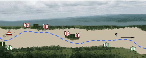
ñ Dredging works (220.000 m°); and
ñ Removing rocks from critical sections (12.000 m°).
Considering market values (US$3.00/m°, for san dredging), the annual draft maintenance costs
will be around US$600,000 (R$2.4 million). Market value for the rocks removal is around
US$120/m°, resulting in a total cost of US$1,440,000 (R$5,184,000.00).
Figure 9 Ù Simulation of the signalization and buoys in the SÐo Francisco Hydroway.
According to the Report on the "Situation of the Complementary Works for the SÐo Francisco
Hydroway (December/2002) Ù Strategical Programs (AvanÓa Brasil)":
ñ 90% of the signalization works and dredging of the navigation channel (for maintenance
of a 1.5 draft, between Pirapora and Juazeiro/Petrolina) have been concluded.
ñ The rocks removal works were terminated, with conclusion of 80% of the job.
ñ Construction of towers for lighted signs was halted.
ñ Working permit for the hydroway' maintenance works was issued by the IBAMA.
10.1.2. Adapting the Ports of BaÚa de Todos os Santos
The BaÚa de Todos os Santos is the natural option, given the adequacy of the portuary facilities,
the great depth and the existence or return cargo in the hydroway, especially fertilizers and fuel.
In the short and/or medium run, the best points to locate the bulk solids terminals is in Aratu. It is
fundamental that the terminal allow the access of Panamax type ships, with 55 thousand tons load
capacity and a 14.5 m operating draft. In this aspect, the region of Aratu is privileged, as it is hit
by the Cotegipe Channel, with depth varying from 20 to 23 m. Besides, the region is served by
railway.
xli
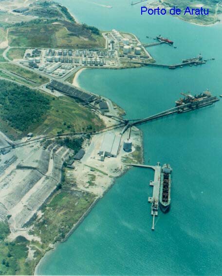
Picture 6 Ù Port of Aratu/BA
Estimated Value (base: Dec./2002)
Based on investments made by Bunge, in the Port of IlhÕus, in 2001, it is inferred that for the
adaptation of the Ports of BaÚa de Todos os Santos for handling grains, the following will be
necessary:
ñ Building warehouse for stocking the grains (soybeans);
ñ Reception equipment; and
ñ A shiploader, with capacity to raise to 750 tons/hour the productivity of embarkment
operations.
These activities' cost is estimate in US$30 million.
To make these investments viable, it is possible to propose a system for integrating the
enhancements in the PortÇs patrimony, after termination of the contract. In counterpart, reduced
fares might be offered. Certainly, enterprises dealing with soy would be interested in the
investments, because both the hydroway and the terminals are strategic for them.
10.1.3. Construction of the Petrolina/Salgueiro segment of the Transnordestina Railway
For making available the Barreiras/BAÙPorto de Suape/PE segment, viewing mainly the outflow
of soy, for export purpose, it is necessary to conclude the construction of the Transnordestina
Railway, linking Petrolina/Juazeiro to the Port of Suape.
xlii
Estimated Value (base: Dec./2002)
For implementing the proposals in the present study, the only requirement within the Railway
project would be the construction of the Petrolina-Salgueiro segment and the
restoration/modernization of the Salgueiro-Recife reach. These activities would require the
following investments:
Reach
Estimated cost (U$ million)
Petrolina-Salgueiro 230,228
Salgueiro-Recife 63,100
Total
293,328
Source: Ministry of Transportation Ù STT/DTF Ù 2001
In addition to the railway works, it will be necessary to adapt Suape's portuary facilities, for
cargo movement. Quantification of costs for adapting the mentioned facilities will depend on the
interest of the enterprises which will operate the terminals. However, they are estimated as
around US$30 million above the values determined for the Ports of BaÚa de Todos os Santos.
xliii